Description:
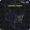
The Lights at Night puzzle features a region of the North American continent at night centered on the contiguous United States as observed by the Visible Infrared Imaging Radiometer Suite (VIIRS) onboard the Suomi National Polar-orbiting Partnership (NPP) satellite. The image was created using data from the VIIRS "day-night band" from nine days in April and thirteen days in October 2012. The file includes a brochure with more information about how the image was made and how the VIIRS lights-at-night dataset is used, as well as several interesting facts and a lights-at-night map quiz.


