
You are here
Joint Polar Satellite System-1 (JPSS-1)
Status:
Current
Mission Category:
Inter-Agency Partnerships
Launch Date: November 18, 2017
Launch Location: Vandenberg Air Force Base
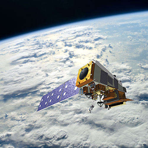
The Joint Polar Satellite System-1 (JPSS-1), or NOAA-20, is the second spacecraft within the National Oceanic and Atmospheric Administration's (NOAA's) next generation of polar-orbiting satellites. Capitalizing on the success of the Suomi National Polar-orbiting Partnership (NPP) satellite, the JPSS-1 spacecraft boasts five similar instruments: (1) VIIRS, (2) CrIS, (3) ATMS, (4) OMPS-N, and (5) CERES-FM6. JPSS-1's design life is seven years, and it is scheduled to launch aboard a Delta-II Mission Launch Vehicle. NOAA is responsible for the JPSS program. NASA is the program's procurement agent, and the agency's Goddard Space Flight Center in Greenbelt, MD, is the lead for acquisition. Data and imagery obtained from JPSS-1 will increase the timeliness, accuracy, and cost-effectiveness of public warnings and forecasts of climate and weather events, reducing the potential loss of human life and property.
Historical Note: The Joint Polar Satellite System (JPSS) is a collaborative program between NOAA and NASA. JPSS is the civilian component of the former National Polar-orbiting Operational Environmental Satellite System
(NPOESS), which was reorganized in 2010.
Key Joint Polar Satellite System-1 Facts
| Launch Vehicle: | Delta II 7920-10C |
|---|---|
| Altitude:Distance from sea level. | 833km |
| Inclination: | 98.7° |
| Local Node:Approximate time, at the equator when vehicle is directly overhead. | 1:30 p.m. |
| Instruments: |
ATMS (Advanced Technology Microwave Sounder) CERES FM6 (Clouds and Earth's Radiant Energy System) CrIS (Cross-Track Infrared Sounder) OMPS (Ozone Mapping and Profiler Suite) VIIRS (Visible/Infrared Imager/Radiometer Suite) RBI (Radiation Budget Instrument) |
Related Publications:
- CERES FM6 (Mission Brochures - 1.97 MB)
Relevant Science Focus Areas:
- Weather
Relevant Science Questions:
- How is the global Earth system changing?
- What are the primary forcings of the Earth system?
Related Applications:
- Weather Prediction