
You are here
Tropospheric Emissions: Monitoring of Pollution (EVI-1) (TEMPO)
Status:
Current
Mission Category:
Earth System Science Pathfinder Program, Earth Venture Class, Earth Venture-Instrument
Launch Date: April 7, 2023
Launch Location: Cape Canaveral Space Force Station
The Tropospheric Emissions: Monitoring of Pollution (TEMPO) mission aims to measure atmospheric pollution covering most of North America, from Mexico City to the Canadian tar/oil sands, and from the Atlantic to the Pacific hourly and at high spatial resolution. TEMPO’s measurements from geostationary orbit (GEO) of tropospheric ozone, ozone precursors, aerosols, and clouds will create a revolutionary dataset that provides understanding and improves prediction of air quality (AQ) and climate forcing.
TEMPO spectroscopic measurements in the ultraviolet and visible provide a tropospheric measurement suite that includes the key elements of tropospheric air pollution chemistry. Measurements are from geostationary orbit, to capture the inherent high variability in the diurnal cycle of emissions and chemistry. A small product spatial footprint resolves pollution sources at sub-urban scale. Together, this temporal and spatial resolution improves emission inventories, monitors population exposure, and enables effective emission-control strategies.
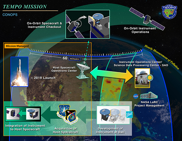
Maxar Technologies and Intelsat agreed to partner to host NASA’s Tropospheric Emissions: Monitoring of Pollution (TEMPO) instrument onboard the Intelsat 40e mission. In 2019, NASA selected Maxar to host the TEMPO instrument utilizing the U.S. Air Force Hosted Payload Solutions (HoPS) contract vehicle. Intelsat 40e is based on Maxar's 1300-class satellite platform and will provide commercial satellite communications for Intelsat customers in North and Central America. The satellite launched into geostationary orbit 22,236 miles (35,786 km) above Earth's equator on April 7, 2023.
This instrument will measure the spectra required to retrieve ozone (O3), nitrogen dioxide (NO2), sulfur dioxide (SO2), formaldehyde (H2CO), glyoxal (C2H2O2), aerosols, cloud parameters, and UV-B radiation. TEMPO thus measures the major elements, directly or by proxy, of the diurnal tropospheric ozone chemistry cycle. Multi-spectral observations provide sensitivity to ozone in the lowermost troposphere. TEMPO will also quantify the daytime temporal evolution of aerosol loading.
TEMPO is part of a constellation of instruments measuring air quality over the Northern Hemisphere that will also include the European Space Agency's Sentinel-4 and South Korea's Geostationary Environment Monitoring Spectrometer.
Key Tropospheric Emissions: Monitoring of Pollution (EVI-1) Facts
| Mission/Portal Page: | http://tempo.si.edu/index.html |
|---|---|
| Launch Vehicle: | SpaceX Falcon 9 |
| Altitude:Distance from sea level. | 35786km |
| Inclination: | 0° |
| Origination: | NASA |
| Instruments: |
UV and Visible Offner Grating spectrometer |
| Principal Investigator(s): |
Kelly Chance, Smithsonian Astrophysical Observatory |
Science Goals:
- Collect simultaneous high temporal and spatial resolution measurements of pollutants over Greater North America.
- Measure the key elements in tropospheric ozone chemistry and aerosol cycles.
- Observe aerosols and gases for quantifying and tracking evolution of pollution.
- Integrate observations from TEMPO and other platforms into models to improve representation of processes.
- Serve as the North American geostationary component of an international constellation for air quality monitoring.
- Determine the diurnal instantaneous radiative forcings associated pollutants and other climate agents on the continental scale.