
You are here
MODIS (2001)
Thumbnail Image:
File:
Description:
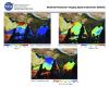
The Moderate Resolution Imaging Spectroradiometer (MODIS) measures the atmosphere, land and ocean processes, (including surface temperature of both the land and ocean), ocean color, global vegetation, cloud characteristics, temperature and moisture profiles, and snow cover. MODIS views the entire surface (land, oceans, clouds, aerosols, etc.) of the Earth every one to two days at a "moderate resolution" of one quarter to one kilometer.
Publication Type: