


Recent Imagery
You will be directed to the NASA Visible Earth webpage when you select Images by Mission below, or click on the images at right that are randomly generated to represent four out of all possible topics.

You are here
Urban Growth
Thumbnail Image:
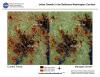
Description:
These images show the extent of land developed as urban, commercial and residential areas between 1986 and 2000, and projected development to 2030 in the Baltimore-Washington D.C. Metropolitan area. Past and current urban extent were derived using Landsat Thematic Mapper (TM) and Enhanced Thematic Mapper Plus (ETM+) satellite images.
Publication Type:
Year (YYYY):
2 002