
You are here
Science Communication Material
NASA's Earth Observing System provides a variety of materials available for download. Feel free to choose a category below:
- Brochures
- Postcards
- Posters
- Science Writers’ Guide
- Mission Brochures
- Fact Sheets
- Calendars
- Booklets
- Lithographs
- Reference and Data Products Handbooks
- iBooks
- Activities
 |
1999 EOS Science Plan (Revised) The Earth Observing System (EOS) Science Plan is the product of leading scientists around the world who are participating in NASA's EOS program. The purpose of the 1999 Plan was to state the concerns and problems facing Earth Science at that time, and to indicate contributions that would be made toward providing solutions to those problems, primarily through the use of satellite-based observations obtained with EOS satellites and instruments. Within this publication, the reader will find types and quality of data expected to be produced from the satellite observations from 1999 forward, how they were expected to improve over existing measurements, and how the data would be applied to solving the problems described. Seven "topical" chapters discuss the nature of the science being reviewed: radiation, clouds, water vapor, precipitation, and atmospheric circulation; ocean circulation, productivity, and exchange with the atmosphere; greenhouse gases and atmospheric chemistry; land ecosystems and hydrology; cryospheric systems; ozone and stratospheric chemistry; and volcanoes and climate effects of aerosols. In addition to the topical chapters, there is a chapter that broadly defines the scope of EOS science. This publication appears in: |
 |
Clouds and the Earth's Radiant Energy System (CERES) NASA’s Earth Observing System (EOS) is part of an international program for studying the Earth from space using a multiple-instrument, multiple-satellite approach. This EOS program is critical for improving our scientific understanding of ongoing natural and human-induced global climate change and providing a sound scientific basis for developing global environmental policies. This is related to the following mission(s): This publication appears in: |
 |
Landsat 7 The flagship EOS satellite, Terra (formerly EOS AM-1), launched in July 1999, is providing key measurements of the physical and radiative properties of clouds; air-land and air-sea exchanges of energy, carbon, and water; trace gases; and volcanoes. Flying in formation with Terra, Landsat 7 is making global high spatial resolution measurements of land surface and surrounding coastal regions. This is related to the following mission(s): This publication appears in: |
 |
Measurements Of Pollution In The Troposphere (MOPITT ) Life on Earth depends on the atmosphere. It provides oxygen for respiration, transports gases around the globe and protects life from harmful ultraviolet radiation. With a human population of over 6 billion, the quality of this life-sustaining envelope is vital to our continued survival. The Canadian Space Agency’s Measurements Of Pollution In The Troposphere ( MOPITT ) instrument is designed to monitor from space the health of this thin layer of atmosphere, and give an early warning of unexpected changes. This is related to the following mission(s): This publication appears in: |
 |
Terra The launch of NASA’s Terra spacecraft in 1999, marked a new era of comprehensive monitoring of the Earth’s atmosphere, oceans, and continents from a single space-based platform. Data from the five Terra instruments are creating continuous, long-term records of the state of the land, oceans, and atmosphere. Together with data from other satellite systems launched by NASA and other countries, Terra inaugurated a new 15-year data record. This is related to the following mission(s): This publication appears in: |
|
|
Terra NASA’s Earth Observing System (EOS) began a long-term, comprehensive study of the Earth with a series of satellites specially designed to study the complexities of global change, an advanced computer network for distributing scientific data, and international teams of scientists who are studying the data. In 1999, NASA launched the EOS satellite Terra to begin collecting a new 15-year global data record on which to base future scientific investigations about our complex planet. This is related to the following mission(s): This publication appears in: |
 |
Advanced Spaceborne Thermal Emission and Reflection Radiometer (ASTER) The only instrument flying on the EOS Terra (formerly AM-1) platform that acquires high-resolution images is ASTER. The primary goal of the ASTER mission is to obtain high-resolution image data in 14 channels over targeted areas of the Earth’s surface, as well as black-and-white stereo images. With a revisit time between 4 and 16 days, ASTER provides the capability for repeat coverage of changing areas on the Earth’s surface. This is related to the following mission(s): This publication appears in: |
 |
Multi-angle Imaging Spectroradiometer (MISR) MISR is flying on the National Aeronautics and Space Administration’s (NASA’s) first Earth Observing System (EOS) satellite—EOS Terra (formerly AM-1)—together with four other instruments designed to study Earth from space. The Jet Propulsion Laboratory (JPL) of the California Institute of Technology built the MISR instrument for NASA. JPL, in collaboration with the MISR science team, built the software to convert raw MISR data into information that Earth science researchers can use. This is related to the following mission(s): This publication appears in: |
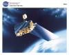 |
Terra NASA’s commitment to studying the Earth as a global system continued with the launch of the Terra spacecraft in December 1999 representing a key contribution by NASA to the U.S. Global Change Research Program. Terra was the first of several EOS spacecraft that are observing the Earth’s continents, oceans and atmosphere. It has five state-of-the-art instruments achieving measurement capability and accuracy never known before. This is related to the following mission(s): This publication appears in: |
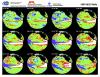 |
1997-98 El Nino (1998) This image shows the progression of the 1997-98 El Niño as derived rom the TOPEX/Poseidon satellite. This publication appears in: |