
You are here
Science Communication Material
NASA's Earth Observing System provides a variety of materials available for download. Feel free to choose a category below:
- Brochures
- Postcards
- Posters
- Science Writers’ Guide
- Mission Brochures
- Fact Sheets
- Calendars
- Booklets
- Lithographs
- Reference and Data Products Handbooks
- iBooks
- Activities
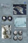 |
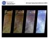
EOS Science: Ice (2007) The EOS Science: Ice poster explains what NASA scientists are doing to study and understand Ice here on Earth. This publication appears in: |
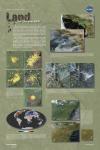 |
EOS Science: Land (2007) The EOS Science: Land poster explains what NASA scientists are doing to study and understand land here on Earth. This publication appears in: |
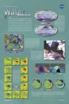 |
EOS Science: Water (2007) The EOS Science: Water poster explains what NASA scientists are doing to study and understand water here on Earth. This publication appears in: |
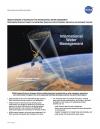 |
International Water Management (2010) NASA’s Applied Sciences Program provides remote sensing and technology information for international water management. Information from NASA is used for society’s benefit, in areas such as water resource planning and management, famine early warning and drought monitoring, food security predictions, disaster management, and water quality. International water management projects are of particular importance in addressing the issues that developing nations and data limited regions face. This publication appears in: |
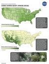 |
Invasive Species (2006) Invasive species may be defined as a non-native plant, animal, or microbe whose introduction causes, or is likely to cause, harm to the economy, the environment, or human health. Increasing globalization—the rapid transportation of people and goods throughout the Earth—provides the opportunity and the mechanism for such species to enter the United States and thrive in new habitats. Each year, the U.S. incurs direct losses of approximately $120 billion dollars due to these invasive species—an annual cost greater than most natural disasters combined. This publication appears in: |
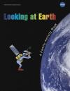 |
Looking at Earth (2009) This 20-page booklet is a collection of games and stories to help in the understanding of our planet’s changing climate. Try these challenging puzzles, while learning how NASA studies Earth’s natural systems. Fun for the whole family! This publication appears in: |
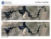 |
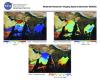
Low Water in Lake Mead (2003) About 96% of the water in Lake Mead is from melted snow that falls in Colorado, Utah, New Mexico, and Wyoming. The past two years have brought severe drought to the western states, and Colorado River runoff has been far below normal during this period. The effect is a drop in lake levels that is visible from NASA satellites. One of NASA’s Earth Science Enterprise research focus areas is the global water and energy cycle governing the precipitation, evaporation, storage and runoff of water. The Earth Science Enterprise Applications Program facilitates the practical use of this knowledge by national and regional decision makers for better management of fresh water resources. This publication appears in: |
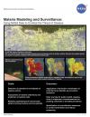 |
Malaria Modeling and Surveillance (2010) The goal of the Malaria Modeling and Surveillance project is to enhance the decision support capabilities of the Air Force Special Operation Command to combat the threat of malaria. The transmission of malaria is influenced by environmental and climatic factors; data from remote sensing instruments are key components to malaria monitoring and control models. Remotely sensed observations, including temperature, precipitation, vegetation density, and humidity, are essential components to this project, as well as Earth science models for climate prediction. This lithograph discusses NASA’s contributions to the Malaria Modeling and Surveillance project. This publication appears in: |
 |
MISR (2001) MISR measures the variation of surface and cloud properties, and particles in the atmosphere, with cameras pointed in nine simultaneous different viewing directions. MISR monitors monthly, seasonal, and long-term interactions between sunlight and these components of Earth’s environment. This is related to the following mission(s): This publication appears in: |
 |
MODIS (2001) The Moderate Resolution Imaging Spectroradiometer (MODIS) measures the atmosphere, land and ocean processes, (including surface temperature of both the land and ocean), ocean color, global vegetation, cloud characteristics, temperature and moisture profiles, and snow cover. MODIS views the entire surface (land, oceans, clouds, aerosols, etc.) of the Earth every one to two days at a "moderate resolution" of one quarter to one kilometer. This is related to the following mission(s): This publication appears in: |