
You are here
Science Communication Material
NASA's Earth Observing System provides a variety of materials available for download. Feel free to choose a category below:
- Brochures
- Postcards
- Posters
- Science Writers’ Guide
- Mission Brochures
- Fact Sheets
- Calendars
- Booklets
- Lithographs
- Reference and Data Products Handbooks
- iBooks
- Activities
|
|
GLOBE Program Lenticular The Global Learning and Observations to Benefit the Environment (GLOBE) Program connects students, teachers, scientists, and other citizens to learn about the Earth environment and climate through data collection, analysis, and research. These data are entered into an international scientific database via website or with apps, and shared for analysis and research by students and scientists from over 100 countries around the world. This publication appears in: |
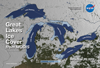 |
Great Lakes Ice Cover from MODIS This lenticular card shows the daily percentage of the lake area covered by ice as derived using data from NASA’s Moderate Resolution Imaging Spectroradiometer (MODIS) on December 25, 2013, and January 25, February 25, and March 25, 2014. The maximum ice extent occurred on March 6 when 92.5% of the surface of the Great Lakes was covered with ice. This is the second most extensive ice cover observed over the lakes since the satellite record began in 1973. This publication appears in: |
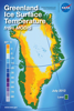 |
Greenland Ice Surface Temperature from MODIS This lenticular card flips between monthly-average ice surface temperature (IST) of the Greenland ice sheet for July 2012 and July 2013, derived using data from NASA’s Moderate Resolution Imaging Spectroradiometer (MODIS) instruments onboard the Terra and Aqua satellites. In July 2012 approximately 99% of the top layer of the ice sheet melted for a short period of time—the greatest areal extent of surface melting in over 125 years. This publication appears in: |
 |
NASA Science Program Support Office Annual Report 2015 During FY2015, the Science Program Support Office (SPSO) supported 24 domestic and international science conferences and public events. Each year the SPSO strives to provide an inspiring and interactive venue, using a unique storytelling approach, that allows a variety of audiences worldwide to connect with NASA Science. The 2015 Annual Report provides a broad overview of these activities, along with details about new Hyperwall stories, publications, social media, key partnerships, and more! This publication appears in: |
 |
NASA's Earth-Observing Missions To study the Earth as a whole system and understand how it is changing, NASA develops and supports a large number of Earth-observing missions. This brochure provides an overview of NASA’s operating and future missions as of October 2015. This publication appears in: |
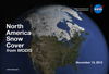 |
North America Snow Cover from MODIS The images on the front show the extent of North America covered by snow on November 13, 2013, and February 13 and April 13, 2014, as derived using data from NASA’s Moderate Resolution Imaging Spectroradiometer (MODIS) instruments onboard the Terra and Aqua satellites. Snow cover extent peaked in February when approximately 67% of the contiguous United States was covered with snow—282,000 square miles (~730, 400 square kilometers) (roughly the size of Texas) above the 1981-2010 average. This publication appears in: |
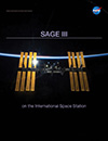 |
SAGE III on the International Space Station NASA’s Stratospheric Aerosol and Gas Experiment (SAGE) family of remote-sensing-satellite instruments has long measured ozone (O3) concentrations, stratospheric aerosols, water vapor, and other trace gases that influence Earth’s atmosphere. Planned for launch in 2016, SAGE III on the International Space Station will continue the legacy of accurate SAGE measurements. This brochure provides details about the instrument, launch and installation, ground system and data, and more! This publication appears in: |
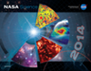 |
2014 NASA Science Mission Directorate Calendar |
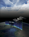 |
CATS: Measuring Clouds and Aerosols from the ISS In 2011 the International Space Station (ISS) NASA Research Office offered scientists at NASA’s Goddard Space Flight Center a mounting location onboard the space station for a new lidar instrument called the Clouds and Aerosol Transport System (CATS). Described in this brochure, CATS provides vertical profiles of cloud and aerosol properties at three wavelengths (1064, 532, and 355 nanometers). The CATS mission seeks to build on the CALIPSO data record, provide observational lidar data to improve research and operational modeling programs, and demonstrate new lidar retrievals of clouds and aerosols from space. These technologies and the science gained from the CATS mission will be used to design future missions that will study clouds and aerosols and their affects on Earth’s climate and air quality for years to come. This is related to the following mission(s): This publication appears in: |
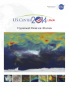 |
COP-20 Hyperwall Content This brochure provides information about the content displayed on NASA's Hyperwall in the U.S. Center at the twentieth session of the Conference of the Parties (COP-20) held December 1-12, 2014, in Lima, Peru. This publication appears in: |